NEWSROOM
UNIVERSITY OF GENOA - SURVEY REPORT UNDER EU4NATURE
1. INTRODUCTION
The Department of Civil, Chemical, and Environmental Engineering from the University of Genoa (DICCA-UniGe; https://dicca.unige.it/en ) is currently involved in the EU4Nature Action, financed under the contribution agreement IPA III/2023/445-342 and aimed at protecting, preserving and restoring at least 25% of Albania’s terrestrial and marine territory. In this respect, thanks to the knowledge and expertise in the field of maritime hydraulics and constructions, DICCA is working to support the activities concerning the management of marine protected areas (MPA), particularly focusing in the bay of Porto Palermo and the Narta Lagoon (see Figure 1). After a preliminary inspection of the areas during the first reporting period (October 2024 – February 2025), which resulted in an inception report.
A second survey was carried out from May 26 to May 30, 2025 by a multi-disciplinary team from DICCA and the Department of Earth, Environment and Life Science (DiSTAV) from the University of Genoa.
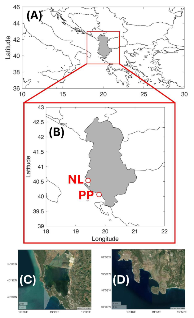
Figure 1. Panel A: Map of Albania in Eastern Europe. Panel B: Close-up view highlighting the Narta Lagoon (NL; see Panel C) and Porto Palermo Bay (PP; see Panel D).
The objective of it was threefold:
1) To monitor the status of the seagrass meadows nearby the artificial reefs (AR) deployed in the northern part of the Porto Palermo bay under a previous project (Naturalbania BLUE coAL-Ition; https://www.celim.it/it/progetto/sviluppo-sostenibile-del-patrimonio-naturale-e-culturale/ ). This analysis aims to evaluate the feasibility of seagrass reforestation intervention, as well as the long-term effectiveness and sustainability of such measure;
2) To geo-reference the AR and monitor their performances. As stated in the inception report, the UniGe team in charge of their deployment could not be present when these were sunk due to delays in custom clearance. As such, this survey was needed to identify the exact UTM positions of the reef, with the aim of possibly expanding the fields and eventually developing a web-GIS to support “blue trails” for scuba divers. Meanwhile, the team documented the local fauna that developed around the AR to assess their capability in enhancing marine biodiversity;
3) To inspect the drainage channel flowing into the Narta Lagoon from the nearby city of Vlorë. This action was meant to evaluate the possibility of reducing lagoon pollution by intercepting floating debris collected and transported by the channel.
2. SEAGRASS MEADOWS IN PORTO PALERMO
Seagrasses are common in coastal areas, typically down to ≈30 m depths, and form meadows originating complex habitats that are crucial for the marine environment. These meadows provide essential breeding and feeding grounds for many marine organisms, promote carbon sequestration and, by mitigating wave propagation, they can ultimately reduce sand loss and coastal erosion by trapping sediments on the sea bottom. While representing a key factor for the well-being of coastal environments, these habitats are highly threatened by human activities, and in particular fish-farming, dredging, and unregulated mooring. Unfortunately, regression trends have been observed across all Mediterranean seagrass populations, and these are expected to continue in the future.
The above concerns are relevant as well to the bay of Porto Palermo. Aerial imagery of the area reveals artificial patterns indicative of the loss of seagrass, as shown in Figure 2. Darker regions indicate indeed that the sea bottom is covered with meadows, which, by contrast, is lost where brighter areas are found. Such patterns are undoubtedly related to anchors dragging from the numerous boats visiting the bay, especially during the summer months, as no other significant anthropic pressures are present in the area. This is further illustrated in Figure 3, which was taken during one of the inspections at the AR. It is therefore evident that any initiative for the reforestation of seagrasses will inevitably fail unless mooring activities are properly regulated.
Based on these grounds, the most urgent action seems to be the installation of floating mooring buoys to prevent the damage of seagrass plants by the anchors. In this respect, previous research demonstrated the benefits resulting from the deployment of advanced mooring systems such as those shown in Figure 4, which prevent the contact between the seabed and the mooring chain, with registered increase in the meadows density up to 100%.
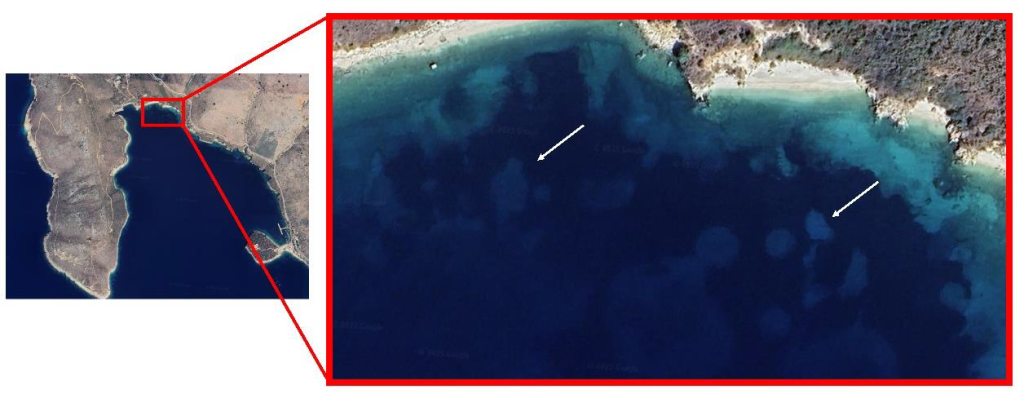
Figure 2. Mooring scars in the proximity of the coastline in the northern bay. White arrows indicate a couple of examples where seagrass meadows have been accidentally removed.

Figure 3. Seagrass uprooted from the anchor. Photos taken by Francesco De Leo on May 26th 2025.
However, it is worth noting that the advanced mooring systems are particularly convenient in macro-tidal environments, i.e., those showing excursion with respect to the mean water level higher than 2 m. Given that Porto Palermo experiences negligible tidal variation, a conventional system (such as the one shown on the left side in Figure 4) would suffice to prevent accidental uprooting caused by mooring chains. The adoption of a floating mooring system would not only protect the existing meadows, but would also prevent the uprooting of the ones possibly planted through the restoration project.
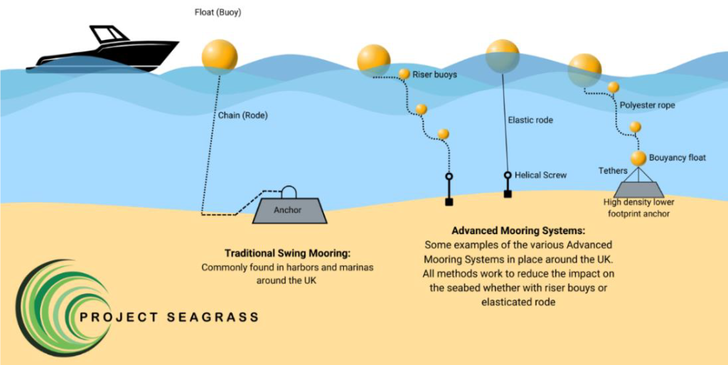
Figure 4. Examples of floating moorings aimed at preserving seagrass meadow (adapted from: https://www.projectseagrass.org/).
As a matter of fact, newly planted seagrasses are particularly fragile, and lack of protection from uncontrolled mooring would inevitably yield a complete failure of the action.
The evaluation of the ecological status of the existing Posidonia oceanica meadows in the bay was investigated by two marine ecologists and scientific divers from DiSTAV, i.e., Dr. Ilaria Mancini (SNSI Deep Diver; PhD Student) and Dr. Muriel Oddenino (PADI Dive Master; Research Fellow). They conducted two depth transects within the portions of Posidonia oceanica meadows adjacent to the two artificial reef installations. The transects were carried out starting from the lower limit of the meadow and proceeding shoreward using an underwater compass, in order to collect the following information:
– Depth and type of lower limits, distinguished in shaded, sharp, erosive, and regressive8. The depths of the lower limits will be compared with the classifi-cation of the ecological status proposed by UNEP/MAP-RAC/SPA (2011);
– Substrate type (sand, rock, dead matte);
– Coverage of seafloor by live Posidonia oceanica, dead matte and of any other substitutes (i.e. Cymodocea nodosa, Caulerpa cylindracea, Caulerpa taxifolia). Visual cover estimation was performed by the two divers independently as to derive more robust results;
– Shoot density of P. oceanica, assessed through six replicate counts of shoots using a 20 cm × 20 cm square frame at three stations located respectively at the lower limit, the central portion of the meadow at a depth of 15 m, and the upper limit of the meadow The measured density values will be subsequently standardized to 1 m2 and classified according to the classification of the eco-logical status proposed by the United Nations Environment Programme and Mediterranean Action Plan (UNEP MAP RAC/SPA, 2011).
The collected data will allow for the calculation of several ecological indices, to understand the health status of the meadow: Conservation Index, Substitution Index, and Phase Shift Index, and will complement the information collected during previous reports as outlined below:
– Ecological study in the Porto Palermo Bay and surrounding areas. Published by RAC/SPA. Year 2015. Document elaborated within the framework of the Regional Project for the Development of a Mediterranean Marine and Coastal Protected Areas (MPAs) Network through the boosting of Mediterranean MPAs Creation and Management (MedMPAnet Project);
– Studio sull’habitat marino della zona di Porto Palermo di Himara con focus sulla presenza di Posidonia oceanica e raccolta di materiale fotografico divulgativo. Luigi Mucerino & Andrea Scuteri – GEOSCAPE Società cooperativa. Year 2022. Document elaborated in the framework of the NaturAlbania project;
-EU4Nature – Inception report. Year 2025. University of Genoa.
The data collected during field surveys, along with the localization and extent of the possible reforestation areas, will be the object of a technical document elaborated by the marine ecologists from DiSTAV, supporting the design and implementation of nature-based solution models in the area.
3. AR IN PORTO PALERMO: STATUS AND PERSPECTIVES
A total of 18 Artificial Reefs (AR) were installed in 2022 in Porto Palermo bay under the Naturalbania project. Of these, 12 were deployed in the northern sector of the bay and 6 in the southern one. Inspections took place on May 26th and May 27th (mon-tue) and interested solely those in the northern sector to maximize resource efficiency and to avoid interfering with the aquaculture facilities located in the southern bay.
On the basis of the inputs from local stakeholders, the UniGe team successfully identified the two installation sites and georeferenced each AR. Besides, pictures and dimensions of each AR were collected and stored in a Geographic Information System (GIS) (an online freely accessible version of the GIS will soon be available). A total of three visual census transects were conducted at each AR site. Each transect lasted 4 minutes. The abundance of all fish species encountered along each transect was recorded by the two trained scientific divers of DiSTAV.
A preliminary list of the main fish species observed during the visual census in the vicinity of the artificial reefs is reported below:
- Moray eels (Muraena helena) – Three individuals were found using the artificial reefs as dens (see Figure 5B);
- Montagu’s blenny (Coryphoblennius galerita) – A single individual was observed;
- Saddled seabream (Oblada melanurus) – Approximately 40 individuals observed;
- Goldblotch Grouper (Epinephelus costae) – A single individual was spotted;
- Painted Comber (Serranus scriba) – Around 7 individuals were observed;
- Blotched Picarel (Spicara maena) – Around 8 individuals were observed;
- Mediterranean rainbow wrasse (Coris julis) – Around 10 individuals were detected;
- Comber (Serranus cabrilla) – Around 10 individuals were observed;
- Small Triplefin Blenny (Tripterygion melanurum) – A single individual was spotted;
- Common two-banded seabream (Diplodus vulgaris) – Approximately 10 individuals observed;
- Ornate wrasse (Thalassoma pavo) – Approximately 20 individuals observed;
- Damselfish (Chromis chromis) – Around 60 individuals were observed (see Figure 5A).
The analysis of the data collected on fish taxa and their abundance will allow evaluating the role of AR in enhancing biodiversity of associated communities.
Next, a visual survey of the infralittoral rocky reef communities developing on the artificial reefs was also conducted using the bionomic quadrat technique, within which the coverage of the various conspicuous taxa was visually estimated. This sampling was carried out by the scientific divers for each reef at both stations (i.e. East and West field). The analysis of the identified community will allow to investigate the structure and ecological status of the communities associated to the artificial reefs through the application of diversity indices such as Shannon’s Diversity Index (H’) and Simpson’s Dominance Index (D).
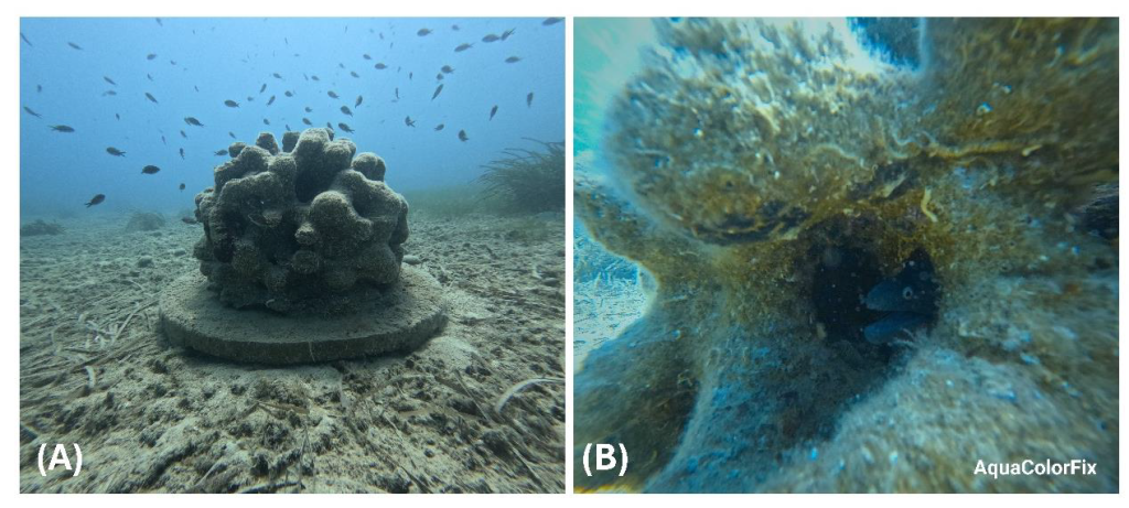
Figure 5. Panel A): Damselfishes nearby an AR; panel B): a moray eel nesting in an AR.
While the above fish species are common in the Mediterranean Sea, their presence was recorded almost exclusively around the ARs—at least at those depths—highlighting the ecological value of these structures and supporting the case for additional deployments.
The aesthetic appeal of these structures, coupled with the potential for creating even more complex forms through advancements in 3D printing, enhances their role in supporting marine biodiversity. Their design and ecological function also offer opportunities for developing underwater trails that could attract scuba divers and promote a sustainable ecotourism industry.
Figure 6. Maps of the AR visualized in the Q-GIS environment. Pop-ups show the tables associate to each AR, reporting the depth (Z), ID (AR), height, diameter, and their possible overturning (flip).
It is worth noting that two ARs located at the eastern site (numbers 4 and 5 in Figure 7) were found overturned, likely due to rotation during their sinking. These units were installed at greater depths, where wave-induced currents are minimal, making environmental stressors an unlikely cause. Furthermore, the absence of physical damage suggests that the displacement was not due to anchoring activities.
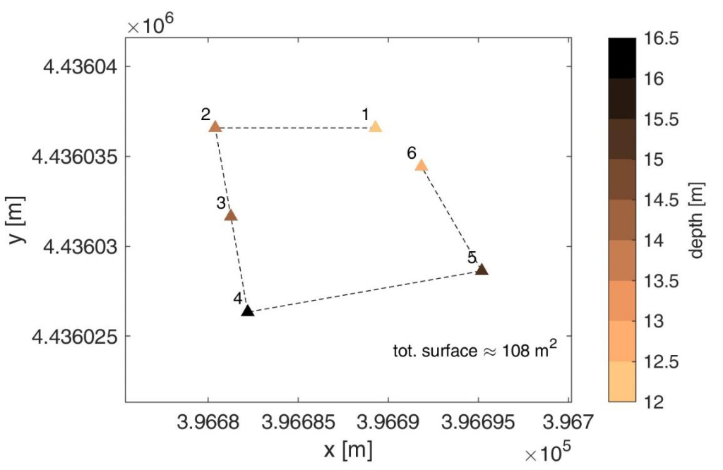
Figure 7. Position and depth of the AR in the East field. Reference system EPSG: 32634.

Figure 8. Position and depth of the AR in the West field. Reference system EPSG: 32634.
4. ACTIVITIES IN THE NARTA LAGOON
On May 29th the UniGe team visited the turtles rescue center in Vlorë, and presented the preliminary results of their activities to delegates from the Italian Agency for Cooperation and Development (AICS), the Regional Agency for Protected Area (RAPA), Agjencia Kombëtare e Zonave të Mbrojtura (AKZM), and the NGO Centro laici italiani per le missioni (CELIM). Later on the same day, the team went to the Narta Lagoon to inspect a few spots that were identified as possible destination for two monitoring devices:
1) A water level sampling device. A similar device had been operative at the hydrovore in 2022 for the Naturalbania project. Given the need for a continuous power supply, a suitable location was deemed to be the Zvernec monastery (see Figure 8 and Figure 9A), although for hydrodynamic monitoring it would be more convenient to place the device close to the south inlet. However, no power sources were detected there and therefore this was excluded. During the inspection the gate of the inlet was found closed, as noted in several previous surveys.
2) A coastal monitoring station based on CoastSnap. This is a low-cost, citizen science technology allowing to extract the shoreline position and ultimately helping to assess potential erosive and accretional patterns
However, CoastSnap relies on the continuous supply of pictures by citizens, thus it only works in crowded places. Hence, the location initially identified was excluded as it is hard to reach and only visited during the summer months, as confirmed by local partners. Coastal monitoring will be therefore put on hold, and other beaches will be possibly considered in the near future.
Previous studies and reports highlighted the delicate balance of the Narta Lagoon, whose waters are particularly threatened by a reduced exchange with the outer sea. This is especially due to the inlets morphology which, moreover, are manually kept closed during most of the year (see in this respect Figure 9B). In addition to ensure a more efficient regulation of the gates, it would therefore be imperative to limit the external sources of pollution. As regards the latter, the drainage channel shown in Figure 9D was identified as one worth of attention and was therefore inspected by the team. The aim of the survey was to get insights about the feasibility of technologies tailored for intercepting debris (see the Inception report for further details). Unfortunately, the water discharge through the channel does not seem adapt to activate automatic systems, while the slope of the banks and its location out of the way point to an unfeasible manual waste collection. For the above reasons, the channel will be ruled out from the target areas for future interventions under the EU4Nature project, while it remains understood that any initiative must necessarily be discussed and coordinated with the competent local authorities.
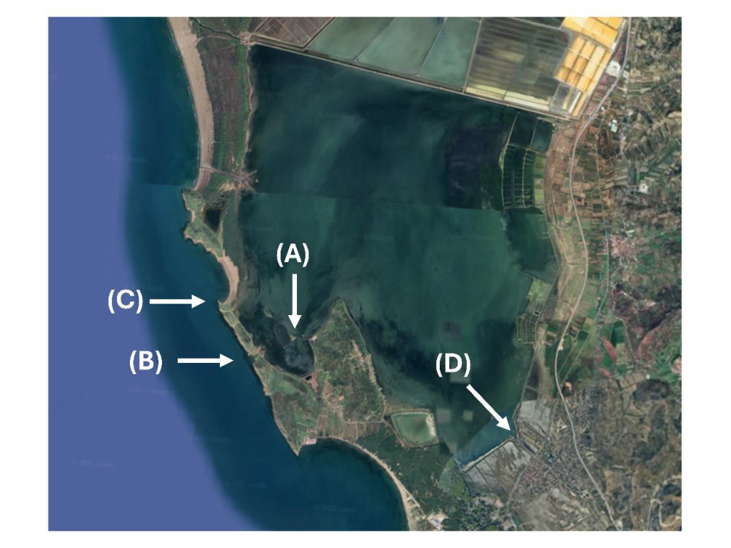
Figure 9. The Narta Lagoon. The labels indicate spots that may be of interest for the EU4Nature Action. A): the Zvernec monastery; B) the southern inlet; C): the beach initially selected for CoastSnap; D): the channel outflow